
A Situated Imaginary: Maps as Mirrors of the Self
Sara Almutlaq
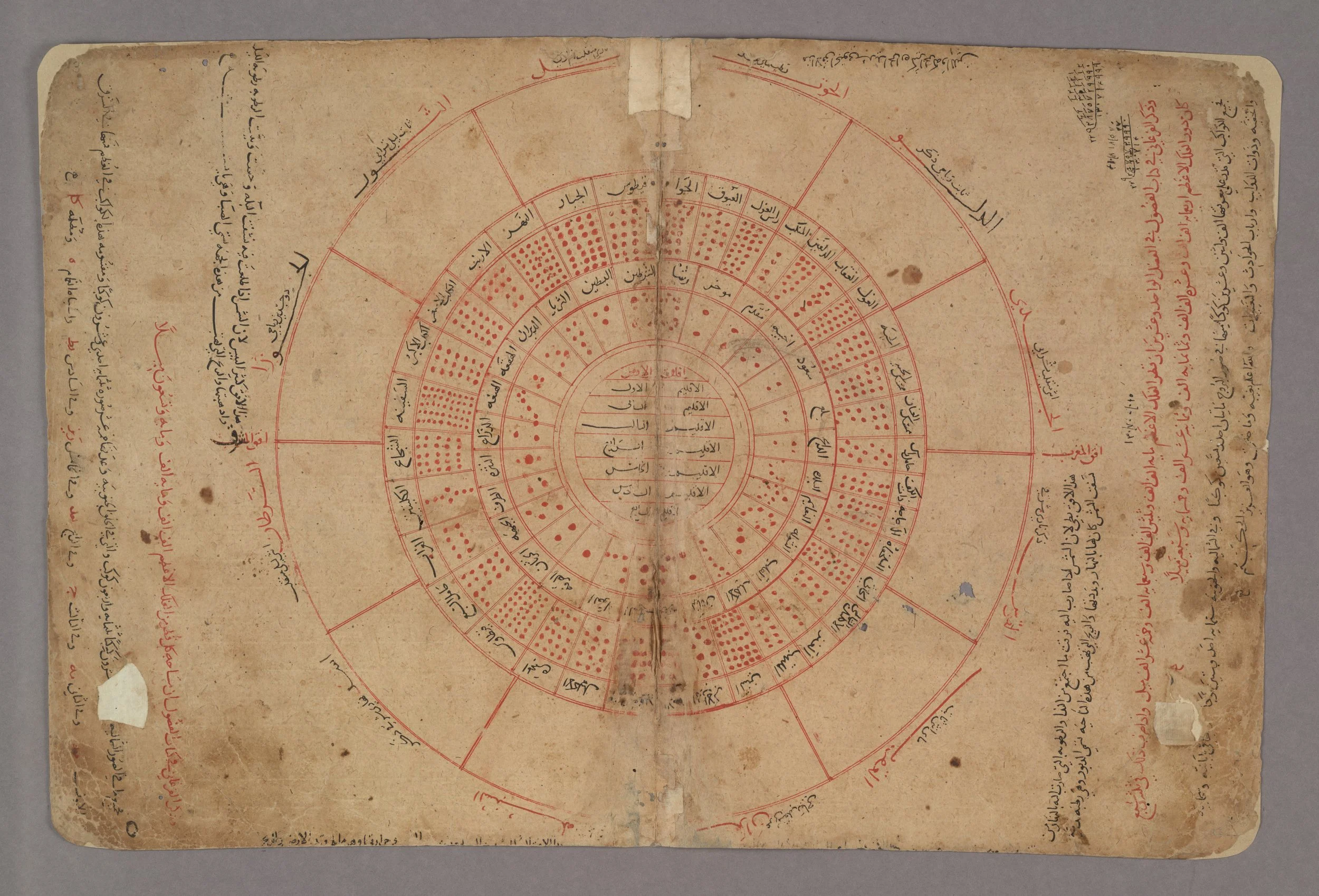
1
Diagram of Seven Climes
Anonymous
Fols. 2b–3a from Kitāb Gharāʾib al-funūn wa-mulaḥ al-ʿuyūn (The Book of Curiosities of the Sciences and Marvels for the Eyes)
Probably Egypt, 1190–1210
Photo credit and courtesy of the Bodleian Libraries, University of Oxford, MS. Arab. c. 90
Across centuries and cultures, maps have imagined the world through a remarkably similar symbolic structure. The exhibition, ‘A Necessary Fiction: Maps, Contemporary Art and Models of Our World’, reveals this unexpected continuity through historical maps, travelogues, cosmographies, and contemporary artworks that reveal a recurring cartographic image. Tracing the genealogy of cartography across Islamic and European traditions, the exhibition argues that maps do not simply describe the world; they reveal an enduring human inclination to belong within it. Despite their radically different visual languages, geographically and historically distant cultures repeatedly arrived at similar cartographic structures. These structures, articulated through centres of self-perception and peripheral imaginaries of beastly otherness, expose a shared operation beneath seemingly disparate worldviews (Forgas, Kruglanski and Williams, 2011). Rather than reinforcing the boundaries these maps once inscribed, ‘A Necessary Fiction’ follows their history to reveal the shared human impulse that unites them.
Today, maps are understood primarily as instruments of navigation: a GPS interface that orient us through increasingly complex urban terrains. However, before cartography became an image, orientation was an embodied practice. Indigenous, desert, and maritime communities navigated through memory, story, stars, winds, currents, coastlines and landmarks. Polynesian navigators read ocean swells and cloud formations across the Pacific, while Bedouin communities crossed the Arabian Desert through accumulated knowledge of stars, winds and shifting topographies. Orientation was produced through an embodied practice and relationship to the world rather than the abstraction of land into an image. The emergence of the map therefore marked a profound shift: embodied, oral and cosmological knowledge was translated into visual models that aimed to organize territory, authority and identity rather than navigation (Harley, 2001).
As societies expanded into settlements representation assumed an increasingly symbolic function. Among the earliest examples are the T–O maps of medieval Europe, inherited from older cosmological traditions dating back to Mesopotamia, such as the Babylonian Imago Mundi (c. sixth century BCE), widely regarded as the earliest surviving world map (Finkel, 2014). These maps are defined by an O-shaped ocean enclosing the known world and a central T-shaped body of water that diagrammatically delineates Europe, Africa, and Asia into a coherent visual order. Their reductive symbolism reflects a subjective description of the world, dividing geography into distinct quadrants of belonging. Geography becomes a diagram of proximity to a centre, and difference is articulated through distance from the world a culture imagines as its own.
From this lineage of symbolic representation, cartography grew as a non-mimetic imaginary, privileging symbolic meaning over geographic resemblance, utilizing scale, orientation and geometry (Pinto, 2016). Here, the innate human inclination to describe oneself, and, in return otherness, gave rise to two poles of the same device: the symbolic centre and the distant periphery. A key example in the exhibition is the Diagram of the Seven Climes, found in the anonymous Kitāb Gharāʾib al-funūn wa-mulāḥ al-ʿuyūn (The Book of Curiosities of the Sciences and Marvels for the Eyes). Born at the intersection of cartographic drawing and the Islamic literary imagination of the ʿajāʾib (Abu-Deeb, 2007), the Seven Climes (fig. 1) articulate an early cosmology of centres and peripheries by dividing the earth into bands of temperature and temperament. The central zones, framed as temperate, habitable, and morally attuned, encompass the familiar landscapes of Mesopotamia, Persia, and the Hijaz, forming a geographical centre through which a culture encounters an image of itself. By contrast, the outer climates drift toward extremes of temperature, physiology, and morality, where the horizon of alterity is projected. Here, the map ceases to describe geography and instead becomes a choreography of proximity and distance, familiarity and fear, revealing a hidden symbolic ordering of the world.
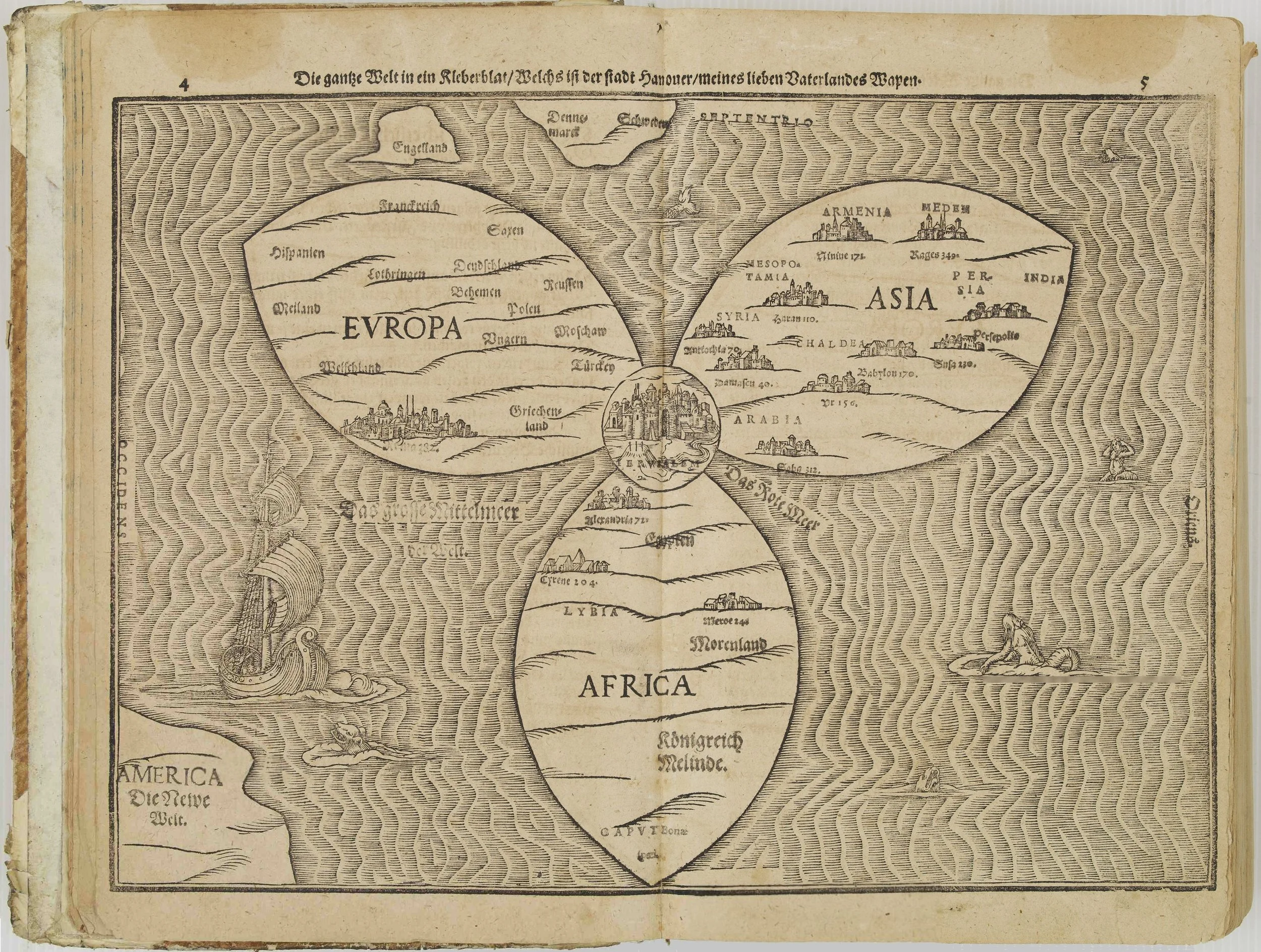
2
The Entire World in a Cloverleaf
Heinrich Bünting (1545–1606)
Folio from Itinerarium Sacrae Scripturae (Travel Guide Through Holy Scripture)
Magdeburg, Germany, 1581
Photo credit and courtesy of Bachhaus Museum, Eisenach
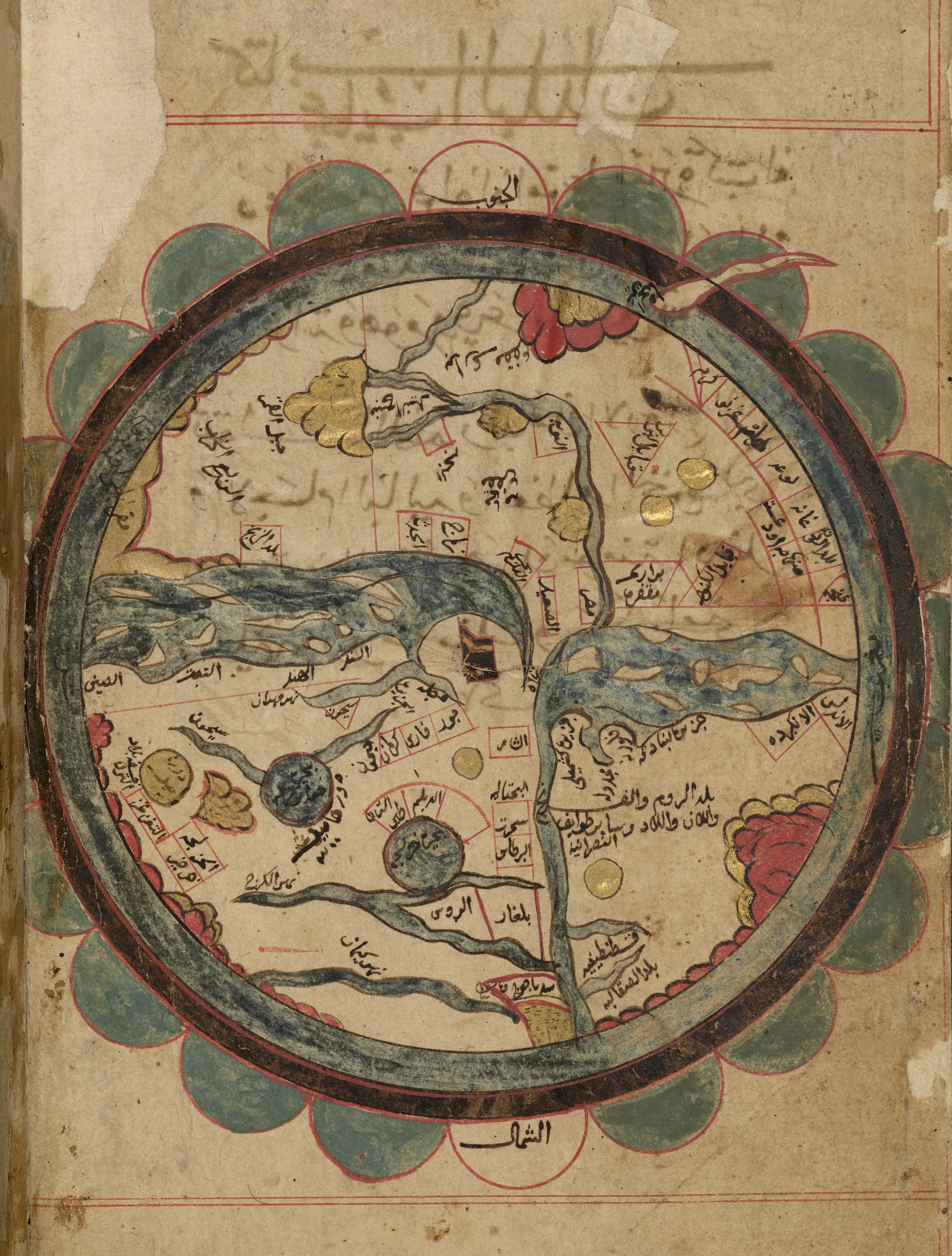
3
Map of the World (Circular Cosmography), folio from Kitāb ʿAjāʾib al-Makhlūqāt wa Gharāʾib al-Mawjūdāt (The Marvels of Creation and the Oddities of Existence)
Zakarīyā ibn Muḥammad al-Qazwīnī (d. 682 AH/1283 CE), copied 990 AH/1582 CE
Courtesy of The University of Manchester Library, Middle East Collections, Arabic MS 668
Photo: The John Rylands Research Institute and Library, The University of Manchester
This symbolic understanding of centrality connects Islamic circular cosmographies like al-Qazwīnī’s ʿAjāʾib al-Makhlūqāt (c. 1275) to medieval European mappa mundi such as Heinrich Bünting's Itinerarium Sacrae Scripturae (1581). Bünting divides the inhabited world into the three continents of Europe, Asia, and Africa through the form of a three-leaf clover, positioning Jerusalem at the centre and orienting the map toward the east (fig. 2). Al-Qazwīnī similarly organizes the inhabited world within an encircling ocean, with the Arabian Peninsula and the Ka’abah in Makkah al-Mukarramah occupying the privileged centre (fig. 3). Here, the familiar orientation of the continents is inverted; the map is south-oriented with Africa appearing to the north and Europe to the south. Both cartographies organize a tripartite world first articulated through the T–O map, yet arrive at distinct spatial arrangements shaped by their authors’ geographic position and worldview. Fact interlaces with fiction, orientation with ideology, until belonging itself becomes an invisible framework through which power and legitimacy are made visible.
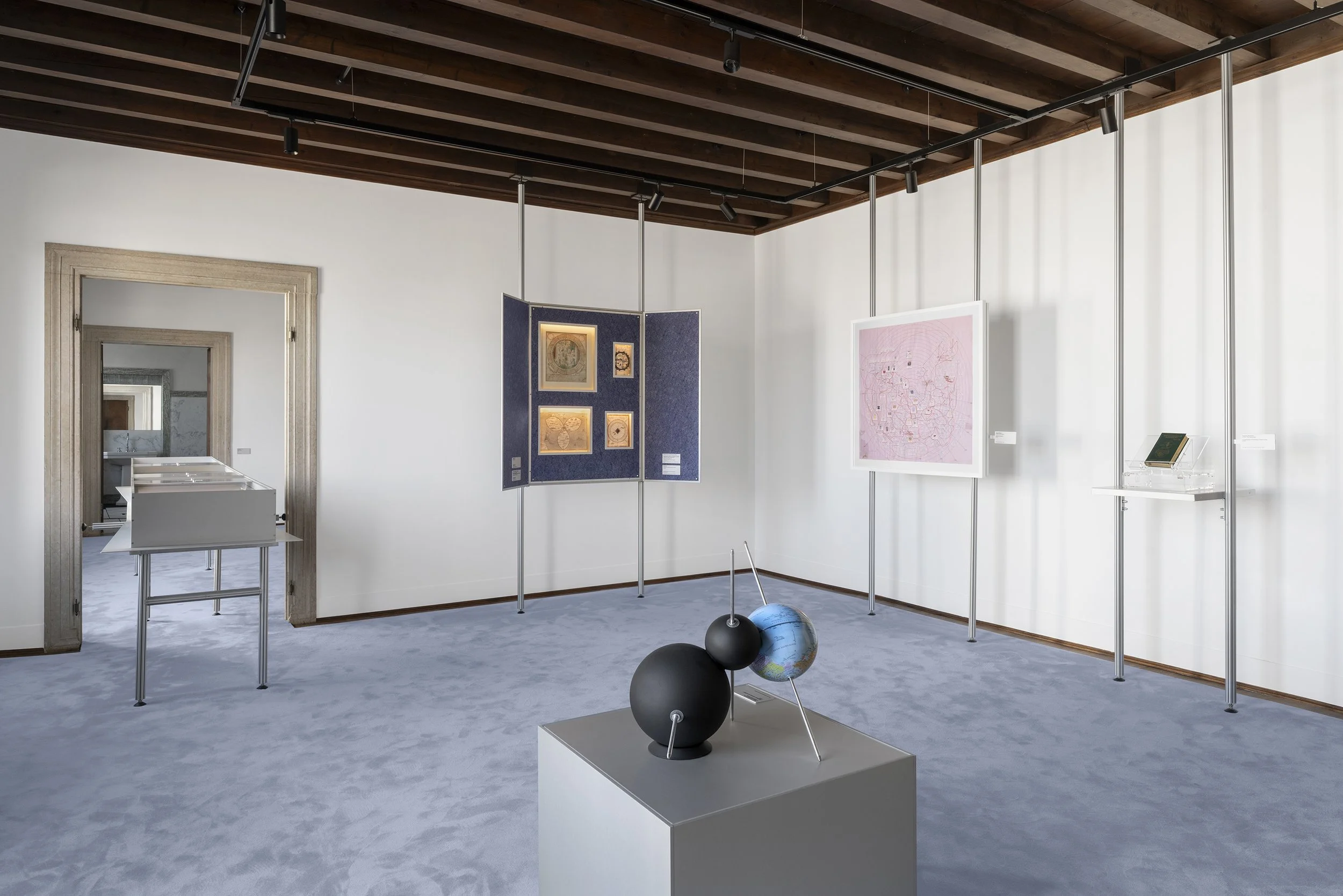
4
Installation view of Multipolar Calibration Model (Black), 2024
By Nolan Oswald Dennis
In ‘A Necessary Fiction: Maps, Art and the Models of Our World’, Abbazia di San Gregorio, Venice, 2026
Original work courtesy of the artist and Goodman Gallery
Installation courtesy of the Ministry of Culture, Saudi Arabia
Photo: © Marco Cappelletti / Marco Cappelletti Studio
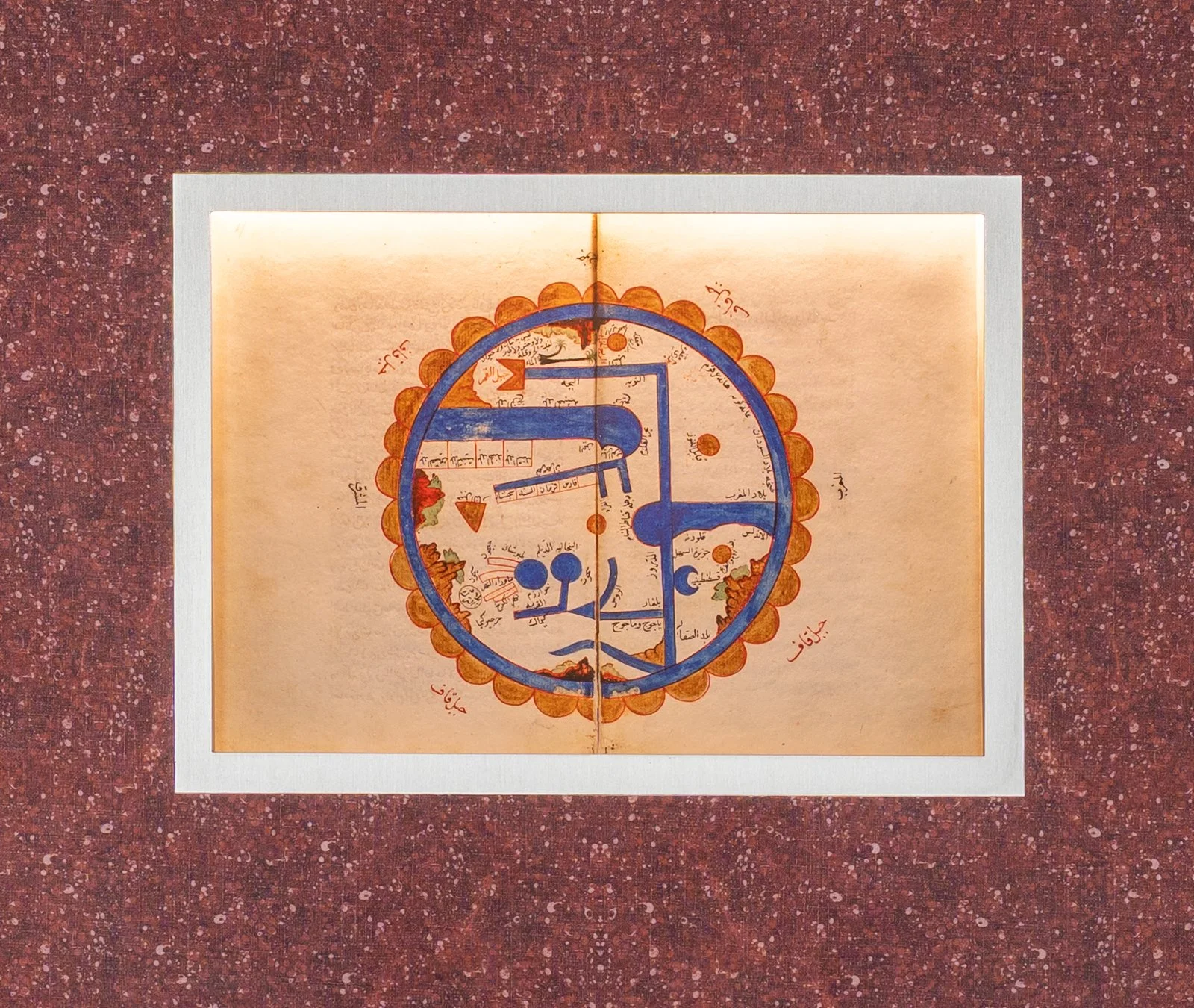
5
Installation view of Map of the World
By Sirāj al-Dīn ibn al-Wardī (d. 749 AH/1349 CE)
Fols. 3b–4a from Kharīdat al-ʿAjāʾib wa-Farīdat al-Gharāʾib (The Pearl of Wonders and the Unique Marvels)
Manuscript dated 984 AH/1576–1577 CE, with later additions including the world map
Photo Credit: © Marco Cappelletti / Marco Cappelletti Studio
Loan Collection: Leiden University Libraries, MS Or. 158
Nolan Oswald Dennis’s Multipolar Calibration Model (Black) (2024) (fig. 4) and Tavares Strachan’s Encyclopedia of Invisibility (2018) extend the cartographic logic of the centre beyond geography into the invisible systems of history, politics, and archival knowledge. Placed alongside Bünting’s Jerusalem and al-Qazwīnī’s Makkah, these contemporary artworks question the authority of the archive, revealing it as another cartographic apparatus through which centres legitimize themselves. Aseel AlYaqoub’s work The Legend of No Legend (2026), unravels the enduring fiction of Arabia Deserta through a hand-drawn palimpsest that overlays medieval mappa mundi, colonial surveys, and satellite imagery of the Arabian Peninsula into an unstable geography inhabited by beasts and contemporary mythologies. In doing so, the work reveals Arabia Deserta not as a geography, but as a cartographic fiction repeatedly reinscribed through systems of representation.
In producing an image of the centre, cartography inadvertently produces an image of its periphery, where the marvellous becomes a structuring force rather than mere ornament, giving form to distance and fear. This is evident in Ibn al-Wardī’s cosmography (fig. 5), where the periphery is articulated through two cartographic devices: the Encircling Ocean (al-Baḥr al-Muḥīṭ) and Mount Qaf. Here, the Encircling Ocean appears as a continuous body of water surrounding the world, while Mount Qaf forms an immense floral barrier marking its outermost limits (Pinto, 2016). Together, they enclose the inhabited world presented in al-Qazwīnī’s Seven Climatic Zones, rendering cosmology into cartographic form. Inscriptions describe these terrestrial frontiers as domains of extraordinary beings including Gog and Magog (Yaʾjūj wa Maʾjūj) and the cross-cultural Blemmyes. A descriptive inscription near the map’s edge further evokes this imagined periphery: ‘contains no plant, no animal, no beast, no bird, overcome by heat and the scarcity of water’.
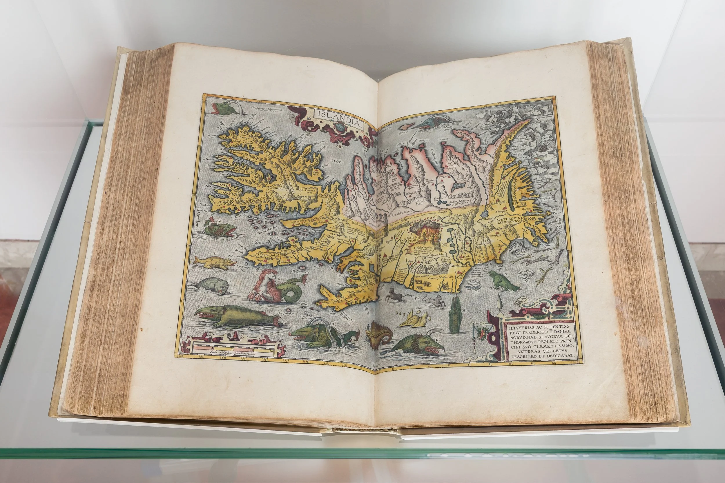
6
Installation view of Islandia, from Theatrum Orbis Terrarum (Theater of the World’s Lands)
By Abraham Ortelius
Antwerp, 1595, posthumous edition published by the Plantin Press
Original work courtesy of Qatar National Library, HC.FB.2016.0053
Installation courtesy of the Ministry of Culture, Saudi Arabia
Photo: Mark Blower
Two centuries later, the same fiction persists in Abraham Ortelius’s Islandia (1595) (fig. 6), which preserves the cartographic inscription of alterity despite emerging from an empirical tradition shaped by maritime exploration and scientific observation. The map’s perimeter, populated by dragons, serpents, and sea monsters, sharply contrasts with the scientifically precise depiction of Iceland at its centre. This imagery is unusual within Ortelius’s Theatrum Orbis Terrarum and reflects the European imagination of Iceland’s volcanic landscapes and extreme climate as a land of marvels and myth. The juxtaposition of empirical geography and mythical imagery reveals the persistence of the beastly within an increasingly measured world, where fiction continued to orient the unknown long after the world’s edges had been charted.
Rather than remaining confined to medieval cosmography, these imaginaries continue to inhabit contemporary artistic practice. In Wael Shawky’s The Gulf Project Camp (2019) (fig. 7), the cosmological imaginaries of al-Qazwīnī re-emerge through a monumental relief where a hybrid creature interrupts the landscape of Makkah. Placed alongside Ortelius’s dragons and Ibn al-Wardī’s Encircling Ocean, Shawky reveals that mythical beasts were never merely decorative motifs, but resilient narrative structures through which societies repeatedly imagined the limits of the known world. By collapsing the distance between centre and periphery, the work reveals that the world is never encountered directly, but always through the centre from which it is imagined. The beast no longer inhabits the edges of the map, but becomes a mirror through which we confront the situated nature of our worldviews.
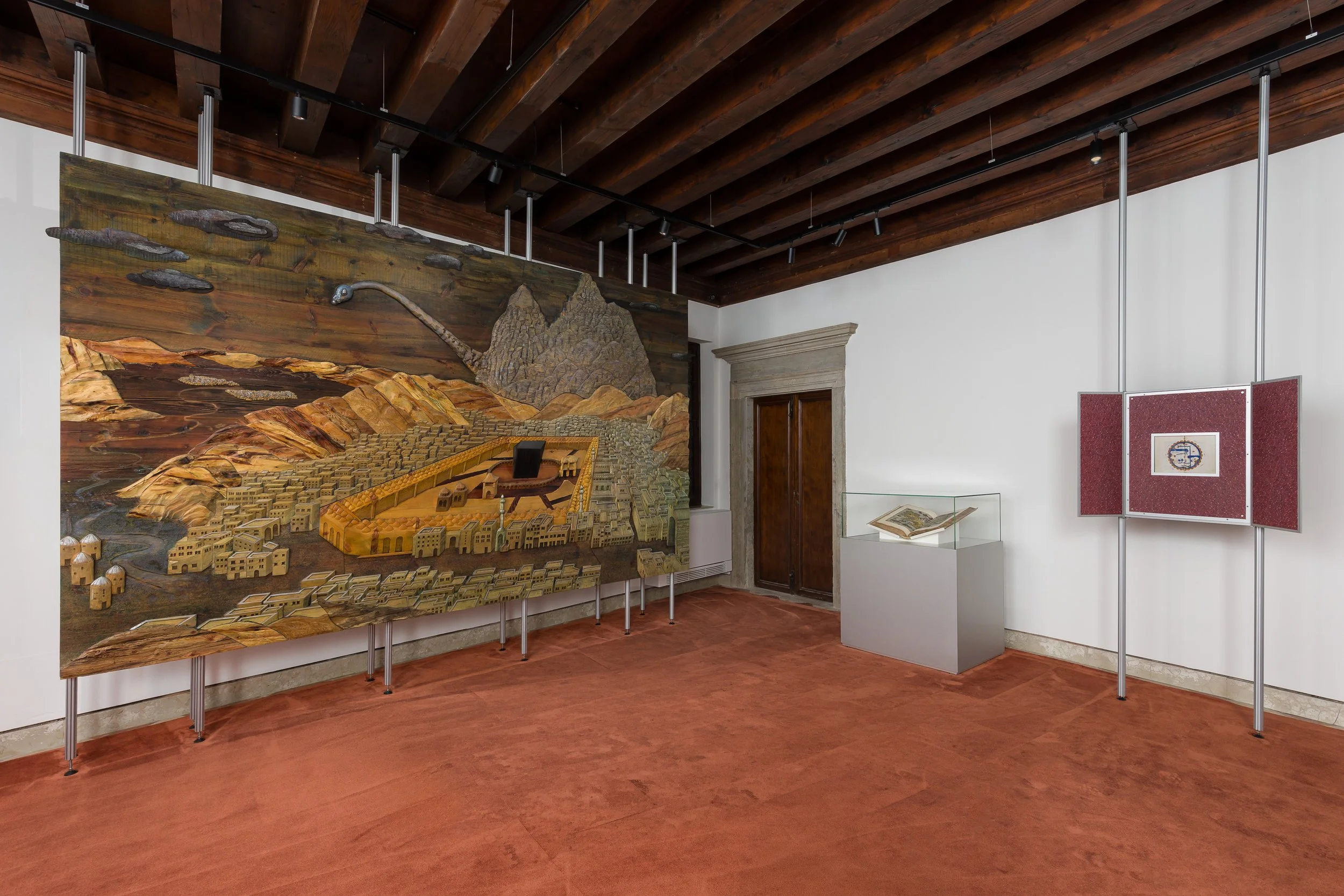
7
Installation view of The Gulf Project Camp (after ‘Hajj (Panoramic Overview of Mecca)’ by Andreas Magnus Hunglinger, 1803), 2019
Wael Shawky
Courtesy of Lisson Gallery
Installation courtesy of the Ministry of Culture, Saudi Arabia
Photo: Mark Blower
Read through a Lacanian lens, the exhibition suggests that maps do not only picture territory; they also stage a relation between self and other. The cartographic centre functions as a collective mirror, while the periphery is populated by figures of alterity, given form as the beastly, the mythical, the marvellous, and the monstrous. This innate orientation in the world is not unique to any civilization, but an elemental human inclination that continues to bind us. Medieval European maps populated their margins with dragons, sea monsters, and fantastical races; Islamic cosmographies imagined distant frontiers through the Encircling Ocean, Mount Qaf, and the poetic language of the ʿajāʾib. Conversely, the non-mimetic manipulation of scale, orientation, and centrality anchored a civilization’s image of itself, while giving form to what lay beyond its horizon.
Seen together, these fictions begin to dissolve cultural difference, forming a universal fantasy machine that renders the world coherent through the fictions we come to hold as truth. Placed in dialogue, the exhibited historical maps and contemporary artworks cease to describe different worlds and instead reveal a common cartographic imagination. The dragons, the Encircling Ocean, Mount Qaf, Jerusalem, and Makkah become different expressions of the same human inclination to orient ourselves within the world. The distance between centre and periphery, Self and Other, history and myth, gradually begins to collapse the remarkable continuity of the human imagination. The exhibition is therefore not one about medium, nor simply about the nature of representation, but an attempt to unravel the original human inclination that persists across cultures, histories, and civilizations. In revealing the humanity within the cartographic, ‘A Necessary Fiction’ invites us to look beyond the boundaries of the map, toward the shared imaginaries that have constructed our sense of self and otherness.
Sara Almutlaq is a curator and cultural strategist and the founder and creative director of Bureau Bayn.
Selected bibliography:
Forgas, Joseph P., Arie W. Kruglanski, and Kipling D. Williams, eds. The Psychology of Social Conflict and Aggression, New York, 2011.
Finkel, Irving, The Ark Before Noah: Decoding the Story of the Flood, London, 2014.
Harley, J. B., The New Nature of Maps: Essays in the History of Cartography, Baltimore, 2001.
Pinto, Karen C., Medieval Islamic Maps: An Exploration, Chicago, 2016.
Abu-Deeb, Kamal, The Imagination Unbound: Al-Adab al-ʿAjāʾibī and the Literature of the Fantastic, London, 2007.